The road runs through a defended doorway
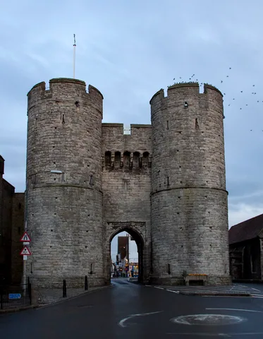
Westgate's two round towers frame an arch at the western approach to Canterbury. The surviving gateway belongs to a late-fourteenth-century rebuilding of the city's defences. It was partly funded by Archbishop Simon Sudbury, at a time when conflict with France made protection a pressing concern.
The opening was practical, but it also announced that entering the city meant passing a controlled boundary. Towers, a gate passage and defensive openings worked together around a route people needed to use.
The building later became a prison. That change gives Westgate two related stories: keeping threats outside, then keeping particular people inside.
Compare the outside with the city face
The round towers present a strong frontage towards the approach. Behind them, the city-facing side has a different character, including windows serving rooms above the passage. The gate needed internal accommodation as well as an intimidating exterior.
Look for the narrow defensive openings and the space through which the gate could be secured. These details make more sense when related to the arch below. Protection depended on controlling a small point in a much longer city wall.
The towers now stand more separately than they once did. Later road and prison works altered the structures around them, so the present view does not show an intact medieval circuit.
The gate became a city gaol
In 1453, Henry VI allowed Canterbury to maintain a gaol at Westgate. The castle served a different jurisdiction as the county gaol. Two places of confinement could exist in the same city because they answered to different authorities.
Prison arrangements expanded beyond the medieval tower, including the later buildings on Pound Lane. Eventually confinement gave way to other uses, and the gate's museum opened in 1906. The rooms became places to explain the history they had helped create.
The museum and battlement viewpoint have separate visiting arrangements, with narrow stairs rather than step-free access. If you remain outside, compare the approach and city faces from safe public pavements. The arch is part of a live street environment; the map pin identifies the monument, not a place to stand in the carriageway.